Drone Video AnalysisTechnology
Advanced 6-step process transforming drone video into actionable intelligence through photogrammetry, AI analysis, and automated reporting.
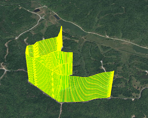
3D Photogrammetric Analysis
Real-time 3D mapping with elevation visualization and precise measurements
6-Step Analysis Process
From raw drone video to actionable intelligence through advanced AI and photogrammetry
Video Capture & Frame Extraction
High-resolution 4K video capture at 60fps with GPS metadata
Process Details
- 4K resolution at 60fps for maximum detail capture
- GPS metadata embedded in every frame
- Automated frame extraction every 0.5 seconds
- Quality assessment and blur detection
- Redundant capture for critical inspection points
Photogrammetry & 3D Reconstruction
Advanced photogrammetry creates detailed 3D models from video frames
Process Details
- Structure-from-Motion (SfM) algorithms
- Dense point cloud generation with 1M+ points per kilometer
- Bundle adjustment for precise camera pose estimation
- Multi-view stereo reconstruction
- Ground control point integration for absolute accuracy
Object Detection & Classification
AI models identify and classify infrastructure and vegetation elements
Process Details
- YOLOv8 and Mask R-CNN for object detection
- 50+ object categories including conductors, poles, vegetation
- Real-time edge processing capabilities
- Confidence scoring for each detection
- Custom models trained on utility-specific datasets
Distance Measurement & Analysis
Precise 3D measurements using calibrated photogrammetric models
Process Details
- Line-to-vegetation clearance calculations
- Conductor sag measurements
- Pole lean and structural deformation analysis
- Automated measurement validation
- Historical comparison and trend analysis
AI Contextual Analysis
Machine learning models assess risk and predict future conditions
Process Details
- Vegetation growth rate prediction
- Weather impact analysis and modeling
- Risk assessment based on 200+ environmental variables
- Seasonal growth pattern recognition
- Regulatory compliance verification
Automated Report Generation
Comprehensive reports with ISA certified arborist validation
Process Details
- ISA Certified Arborist review and validation
- Priority-based work recommendations
- Regulatory compliance documentation
- Interactive maps with flagged areas
- Automated delivery and notifications
Advanced 3D MappingCapabilities
Our photogrammetry technology creates detailed 3D models with millimeter precision, enabling accurate measurements and comprehensive analysis of utility infrastructure.
AI Analysis Capabilities
Advanced machine learning models provide comprehensive analysis across multiple domains
Vegetation Analysis
- • Species identification and classification
- • Growth rate prediction modeling
- • Health assessment and disease detection
- • Clearance violation prediction
- • Seasonal growth pattern analysis
Structural Analysis
- • Pole lean and deformation detection
- • Conductor sag measurements
- • Insulator condition assessment
- • Hardware corrosion analysis
- • Structural integrity scoring
Environmental Analysis
- • Weather impact assessment
- • Terrain and soil analysis
- • Wildlife habitat identification
- • Environmental compliance checking
- • Climate change impact modeling
Interactive Map Output
Real-time visualization with color-coded priorities and detailed inspection results
Critical Priority
Immediate attention required - clearance violations, structural damage
High Priority
Action needed within 30 days - potential violations, maintenance required
Medium Priority
Monitor closely - trending toward violations, scheduled maintenance
Low Priority
Routine monitoring - within acceptable parameters
Map Features
Ready to Transform Your Inspections?
Experience the power of AI-driven drone analysis with industry-leading accuracy and speed.